
If you missed it, and the AMAZING wildflowers, please click here – Across the Woodlines - Hyden to Norseman, Western Australia

Today I bring you part 2 – Eyre Highway and
the Nullarbor. The journey from Norseman in Western Australia
to Ceduna in South Australia (which is classed as being the 'Nullarbor' experience) is
approximately 1,200 kilometres. Are you ready? - please fill up your water
bottles, pack your tent, fasten your seat belts, and make sure you have your
camera ready.
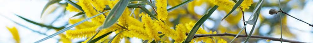
Being far from bare as the word
“Nullarbor” or this collage might imply, there is plenty to explore. Oh my goodness, there is a push-bike rider on the Eyre Highway!

 As we drove across the Eyre
Highway and the Nullarbor we thought about the first Europeans to
cross here – it certainly wasn’t as easy as it is today.
As we drove across the Eyre
Highway and the Nullarbor we thought about the first Europeans to
cross here – it certainly wasn’t as easy as it is today. Aboriginal people, belonging to a number of different language groups, have lived in this vast area of southern Australia for over 35,000 years. There are signs of their heritage in 60 known archaeological sites.
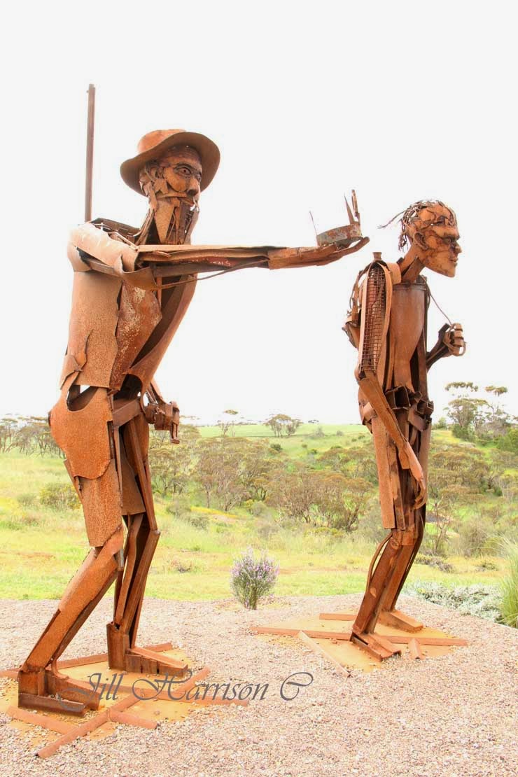
The crossing by Edward John Eyre and his aboriginal companion Wylie in 1840-41 is one of the most remarkable feats of endurance in Australian exploration history. You can see various monuments throughout this part of Australia, including this sculpture dedicated to Eyre and Wylie at Kimba at the top of the Eyre Peninsular....
It was another 30 years before anyone attempted the journey again. An overland telegraph line between Perth and Adelaide (2,425 kilometres and 19,470 poles) was built in 1877 and the first track followed this line. In 1942 a graded road was constructed and the final bituminisation was completed in 1976.
Here is a map showing the Eyre Highway and this part of our trip - the dark blue thick line...

The lack of water was always a problem, and large corrugated iron roofs were erected along the highway to collect run off into tanks. You can still see some of these today - but don't rely on them for water! bring your own!
The ruins of the Eucla Telegraph Station on the border of Western Australia and Adelaide is today being engulfed by shifting sand. Only the ruins of the station master’s residence remain. It is a fascinating place to visit. ……

It takes a few days to cross the Eyre Highway, especially if you are going to stop and look at the sights. There are no towns, but road houses with motels and caravan parks will make the trip easier. There are also a number of free over night rest areas. You can find out about them by going to the Western Australian Main Roads site, click here - Mainroads WA Rest Areas or by purchasing one of the Australian camping guide books.
From the west coast it took us three and a half days and three nights bush camping to reach Streaky Bay in South Australia.
Below you can see them......Newman Rocks, Yalata (don't forget the flyspray and the insect repellent!), Moonera (our camp on our way back), and Jilah Rockhole. The bottom two pics show a typical roadside rest area, and our billy on the boil for that hot chocolate!

One of the best things about bush camping is the sunsets and sunrises that light up the
sky….

Along the road there are trucks and other "big things" (a big kangaroo??). Take care
when overtaking - the trucks I mean.... You will be amazed at what you might see….the bottom RH pic is of a burnt out truck that came to an unfortunate end in a truck bay. Hopefully the driver was unhurt.

Signs to make sure you know where you are ….. like this one warning to
be on the lookout for camels, wombats, and kangaroos. Wombats! We never saw
any but you certainly wouldn’t want to run into one. The camels are feral herds
which have been increasing to huge numbers since the days of the Afghan cameleers
trains carting goods across outback Australia. Also be sure to don’t leave
anything laying about your camp, particularly food, or you might find a dingo
wanders in – and certainly don’t feed them.

And even Royal Flying Doctor landing
strips….yes, there are several of them along the highway - they actually use the highway as their airstrip.….well it
is a straight piece of road!…..It is a quick way to assist people in medical trouble out here.

There is the longest stretch
of straight road in Australia…… and the vastness of the southern Nullarbor Plain - and a sign to tell you when you get there…..

The Nullarbor Plain is the world’s largest limestone karst landscape covering an area of 270,000 square km, extending 2000 km between Norseman and Ceduna. Two thirds of the Nullarbor is within Western Australia and one third is in South Australia.The spectacular Bunda Cliffs and the Great Australian Bight border the area to the south and the northern border is the Great Victoria Desert.
In 1866 E. Alfred Delisser surveyed the Nullarbor Plain and noted a marked absence of trees. Contrary to some popular opinions the word Nullarbor is not of Aboriginal origins. In fact the local Mirning people referred to the area as "Oondiri" which is said to mean "the waterless". Delisser derived the term Nullarbor from the Latin "nulla" for no, and "arbor" for tree. Hence the term "Nullarbor" meaning “no trees”.
However the plain is covered with bluebush and
saltbush plants, hardy shrubs that are drought-resistant and salt-tolerant, with Myall acacia woodlands at the other edges.

There are no towns between Norseman and Eucla, but there are Road Houses to fuel up your vehicle and you….however expect to pay high prices
for fuel and food. You can also buy a shower. Make sure your vehicle is reliable before crossing the
Nullarbor as mechanical repairs will be expensive and time consuming -
especially if parts have to be freighted in.

There are cliffs and whales…….The Great
Australian Bight Marine Park is a significant breeding and calving area at the
Head of the Bight for the Southern Right Whale, and for sea lion colonies along
the Bunda Cliffs. Whale watching at the Head of the Bight between June and
October is a must for Nullarbor travellers. The access to the Head of the Bight lookout is 11km
east of Nullarbor Roadhouse (please note you have to pay to go out on the Head of the Bight lookout). Between
Eucla and the Head of the Bight the Eyre Highway runs quite close to the cliff
edge and there are various lookouts (don't climb over the railings). This is the Southern Ocean - next stop is Antarctica.

At Border Village (on the border of WA &
SA) you go through the Quaratine Station (if travelling east to west)……don’t
carry any fresh fruit or vegetables (travelling west to east the quarantine station is at Ceduna). Please check the website and know what you
can and can’t carry, it is easier that way….click on the link for an easy chart.... Australian domestic quarantine

There is even the Nullarbor Golf Links. This
unique 18-hole par 72 golf course spans 1,365 kilometres from Kalgoorlie
in Western Australia to Ceduna in South Australia. A single hole can be played
in each participating town or roadhouse along the Eyre Highway, each featuring
a green, a tee and a fairway of rugged outback natural terrain. ……make sure you
allow more time for your trip if you intend playing all the holes, and collect
your certificate when you sign up and complete the 18 holes. My son played the Links when he travelled across here a couple of years ago……click on the link to read more - Nullarbor Links
Oh and look out for giant "kangaroos" at the Border Village Link. LOL

At Penong, on the western edge of the South
Australian wheatbelt, you will see a cluster of community windmills in a paddock on the edge of the Eyre Highway. Known as "Windmill Flat" the 26 windmills are each privately owned supplying water for domestic and stock use. Being on the edge of the Nullarbor Plain it is not surprising that water is an issue for Penong. Wells were first sunk between 1868 and 1884 and windmill bores were later sunk to pump water from the Anjutabie Water Basin. Penong still relies on rainfall as their main water source, with additional water carted by tankers from the Todd River pipeline, plus water pumped by the windmills.

We thought is was an unusual sight so I took some pics - and just as well - as my story about Penong's windmills appeared in "Curious Australis" in the February 2014 edition of On The Road Magazine Australia.

At Fowlers Bay you can learn more about Matthew Flinders who named Fowlers Bay in 1802, and Edward John Eyre and his expedition which left here for the crossing of the Nullarbor on 25 February 1841. In the collage below you can see the jetty, a memorial to Flinders, a new hotel, the old telegraph station (now a private residence), and sandhills and salt lake at the edge of town. ….. I really like the way they have converted the old rail cart into a table and seats.

At Fowlers Bay you can learn more about Matthew Flinders who named Fowlers Bay in 1802, and Edward John Eyre and his expedition which left here for the crossing of the Nullarbor on 25 February 1841. In the collage below you can see the jetty, a memorial to Flinders, a new hotel, the old telegraph station (now a private residence), and sandhills and salt lake at the edge of town. ….. I really like the way they have converted the old rail cart into a table and seats.

And at the end of it all you will reach
Ceduna and the start of the next part of our journey. If you are travelling
from west to east the Quarantine Station is here…..

I hope you have enjoyed Part 3 of our tour. I
will be back next week when we go across the top of the Eyre Peninsula, through
the Gawler Ranges where we see the amazing “Organ Pipes” rocks, and a stay in
Port Augusta before turning north up the Stuart Highway and through outback
South Australia.

Mosaic Monday
Travel Photo Mondays
Our World Tuesday
Tuesday Around the World
What's It Wednesday
Travel Photo Thursday
Oh The Places I've Been
You might also like -
On the road through South Australia
Across the woodlines - Hyden to Norseman, Western Australia
Dehydrating food for camping
There I was thinking that the Nullarbor was an area to get through as fast as possible because it would be just more and more of the same. You've made it look like a really interesting adventure Jill, and your collages tell a vivid story. Love the pics of some of the road trains carrying the strangest things, and the idea that the Royal Flying Doctor service uses a section of the straight part as a runway. I had a tour around the RFDS in Kalgoorlie recently - fascinating and awe inspiring. I think what I'd most like to do is bush camp by the side of the road and watch those beautiful unencumbered sunrises and sunsets.
ReplyDeleteBeautiful place :)
ReplyDeleteAmazing trip...90 miles is a long straight stretch, hopefully the scenery keeps one awake. Your country is amazing and I really enjoy seeing the less well known parts of it. A wonderful road trip
ReplyDeleteWhat an epic place for a road trip!
ReplyDeleteGorgeous sunsets/sunrises! The windmills are a favorite too. Nice post.
ReplyDeleteJill, this looks like an amazing trip! So many sights to see. I love the sky shots and the cliff and coastline. The whales are cool too. Awesome post, thanks for sharing your world. Have a happy week!
ReplyDeleteThat was so interesting, both photos and narrative. Thank you for posting. How fortunate you are to have this experience!
ReplyDeleteA fantastic photo journal! I've crossed the Nullarbor, one of my best road journeys in Australia.
ReplyDeletemy goodness you live in Canada, and you have travelled across Australia's Nullarbor! This trip was my first!
DeleteLoved going with you on this trip. I've mainly done it as co-pilot in a small plane hopping from place to place and sometimes re-fuelling at the service station. Oddly enough, there are pockets of trees on the Nullarbor if you know where to look for them. Lovely trip.
ReplyDeleteWhat vast expanses you covered. Such lovely scenery.
ReplyDeleteHi Jill, wonderful collection of the photos! the places looking interesting in your photos.
ReplyDeletethanks for sharing your experience.
# 40 there you are! Yeah, and we are all back again! It looks like you had a great time and shared some beauty, the mosaic that you opened your post with, that is so gorgeous. I must scroll back up and check out the wildflowers too. Hugs~
ReplyDeleteWoah Jill! Now I know where you've been hiding out. What an amazing journey and experience. I don't know where to begin commenting on the photo-text combo that is so evocative and yet packed with historical and geographical info at the same time. An expanse of landscape that I can barely even contemplate from my small island home in the Med. I will now go and read all your installments as I missed those. Love the road sign and the photo of the sculptures of those pioneers of way back when.
ReplyDeleteI always love these journeys you take us (the reader) on, Jill! I kept trying to fathom people making that trip before there was a road. That was cool on those iron roofs still being in tact. The 90 mile road reminded me of the Road Warrior movie! And a golf course in the middle of nowhere? I like how you mentioned about wanting to make sure you had a reliable vehicle! I imagine the road service like we here in the States doesn't respond real quickly that :)
ReplyDeleteHello Jill !! you made beautiful photos of the your trip..
ReplyDeletethanks for sharing your experience with us..
Great post.
Australia is so vast!
ReplyDeleteEver since starting out on the South Pacific to Australia I've used the word vast: the ocean is vast, the distance is vast, Sydney was vast and now this post puts vast even into a more vast perspective! Very interesting, Jill.
ReplyDeleteWhat a great blog, i am searching in google from couple of days” but did not find any great way, but my search came to an end after visiting your blog.!!!Do you have any more related blogs or ideas related to like your this blog, it will help me in my further research work…Will keep following your blogs…
ReplyDeleteBrisbane caravan hire
Wow, what the remarkable tour narrated beautiful with spectacular photographs..
ReplyDeletethanks for sharing your experience with us. and waiting for your next update,..
I love the ruggedness and the harshness of rural Australia. Your shots capture it perfectly. That giant Kangaroo must bring a smile to anyone who drives by!
ReplyDeleteI am glad that you explained that was a wombat in that warning sign or else I would have never figured it out. How fast can you go on the straight road? I'd be tempted to push the accelerator down and see what speed I could reach. Perhaps that is how that burned out truck ended up that way? Your photos certainly demonstrate the scope of what there is to see along the way.
ReplyDeleteLOL - for people who have never seen a wombat you could really wonder what that critter on the sign is! and how big it is! They are heavy solid creatures - you certainly wouldn't want to hit one!
DeleteSpeed limit on the Eyre Highway is 110km/hour maximum speed. Accidents from high speed do happen - hence the Royal Flying Doctor airstrip on the highway!
This comment has been removed by the author.
ReplyDeleteIt's such a vast, beautiful land indeed! The variety of sceneries and things you see along the way is just incredible. I don't think I'll be bored looking out of the window. Must be fun driving a straight road for 90 miles without heavy traffic! I'm afraid I'll tend to overspeed:) Thanks for again sharing another incredible road trip and photos.
ReplyDeleteHi Jill, I love your photos. I have a property to sell in Fowlers Bay and with your permission I would like to use your collage of Fowlers Bay in my advertising. Regards, Nigel Christie Hale Real Estate SA.
ReplyDeleteNext time we have the Nullarbor experience, we'll be taking a bit more time ... that's the probelm with doing it at the end of a 4 month road trip - all you want to do is get home ... and it didn't help tht the weather was HOT and WINDY!! I look forward to seeing what you've shown us in more detail!!!
ReplyDeleteWow, after reading this fantastic blog, I want to visit Australia Now! Check out these Australia Holiday Packages
ReplyDelete